PILOT-DEFINED POSITIONS: LATITUDE/LONGITUDE, PBD AND PB/PB
Pilot-defined points are useful when the intended position is not a named database fix. The Thales standard supports latitude/longitude, place/bearing/distance and intersecting place/bearing definitions. Fenix V3 corroborates NEW WAYPOINT integration and PBD use with DIR TO. That establishes a real feature family; exact storage limits, abbreviation allocation and every supported input variant still require comparison with the loaded implementation. [66, PDF pp. 451-460,650-654,669-670] [82]
1. Choose the definition that matches the source. A supplied coordinate is best handled as a coordinate. The guide's 4600N/100E example means 46 degrees north, 1 degree east; it is a historical syntax example, not our parking position. A reference/bearing/distance definition calls for PBD, and two intersecting reference bearings call for PB/PB. Establish identity, hemisphere, units and bearing convention before insertion. [66, PDF pp. 451-460,650-654,669-670]
2. Enter a complete PBD. The documented grammar is PLACE/BRG/DIST, with three-digit bearing and distance in NM. BIG/090/10 is a synthetic ten-mile point-definition example, not a cleared London fix. Resolve BIG to the intended object first. Read the resulting coordinates and position on the ND; a generated PBD identifier alone does not verify that the correct reference or side was used. [66, PDF pp. 451-460,650-654,669-670]
3. Build an intersection only when it exists. The PB/PB grammar joins each place and bearing with a dash, then separates the pairs with a slash. The source illustrates CGC-30/LMG-330, combining the 030 radial from CGC with the 330 radial from LMG; use the installed field's accepted digit format. These are historical source references. Inspect both places and the resulting intersection; syntactic validity cannot replace a geometric check. [66, PDF pp. 451-460,650-654,669-670]
4. Inspect the generated identity. The source assigns abbreviations such as PBDnn and PBXnn, while coordinate points can also receive shortened names. Open the definition where needed and compare full coordinates rather than relying on the abbreviated label. Two different coordinates may collapse to similar shortened text. Selection on DUPLICATE NAMES must therefore identify the actual geographic object. [66, PDF pp. 451-460,650-654,669-670]
5. Separate defining, storing and using. NEW WAYPOINT can create a pilot record; inserting or directing to that point is a further route action. Review the resulting TMPY and downstream connection before commitment. If a definition is wrong, cancel or correct the record and then inspect all route uses that depend on it. The successful outcome is a verified position and an understood path to/from it, not merely a stored name. [66, PDF pp. 451-460,650-654,669-670]
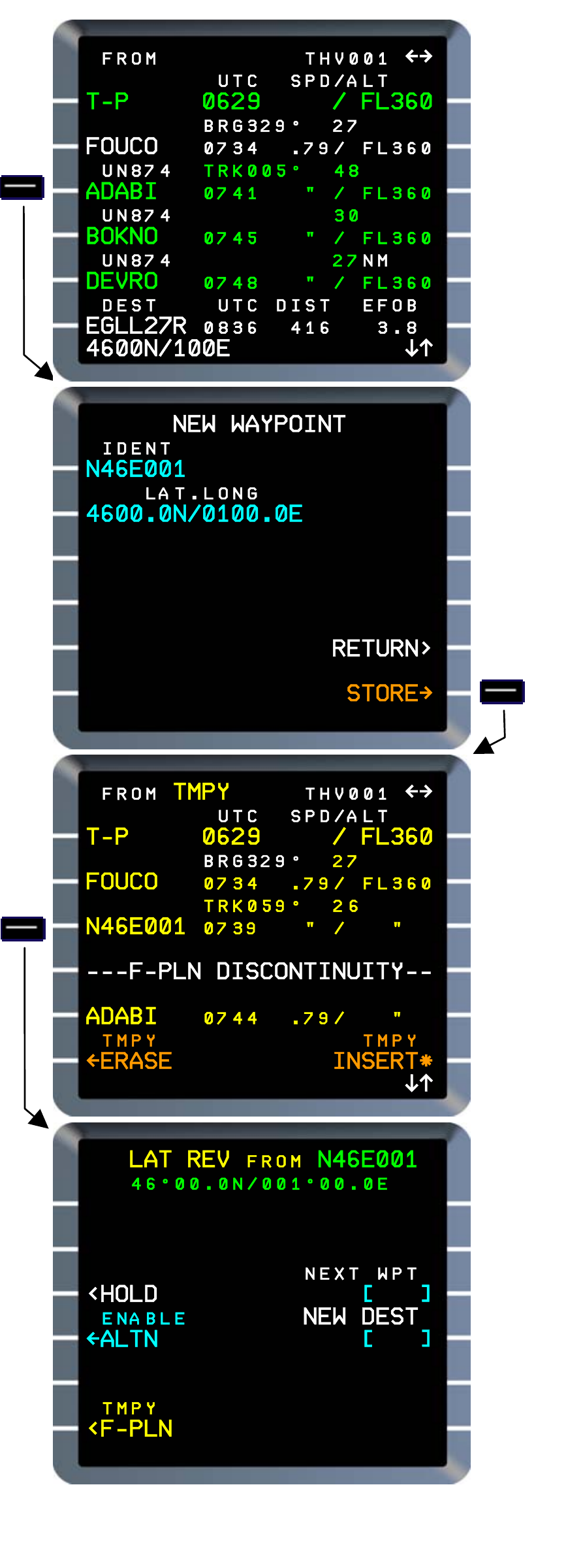
Manufacturer reference: full latitude/longitude definition and shortened waypoint identity in Thales FMS2 REV1. Example coordinates are not a current aircraft position. Fenix V3 NEW WAYPOINT capability is corroborated separately. [66, PDF p. 652]
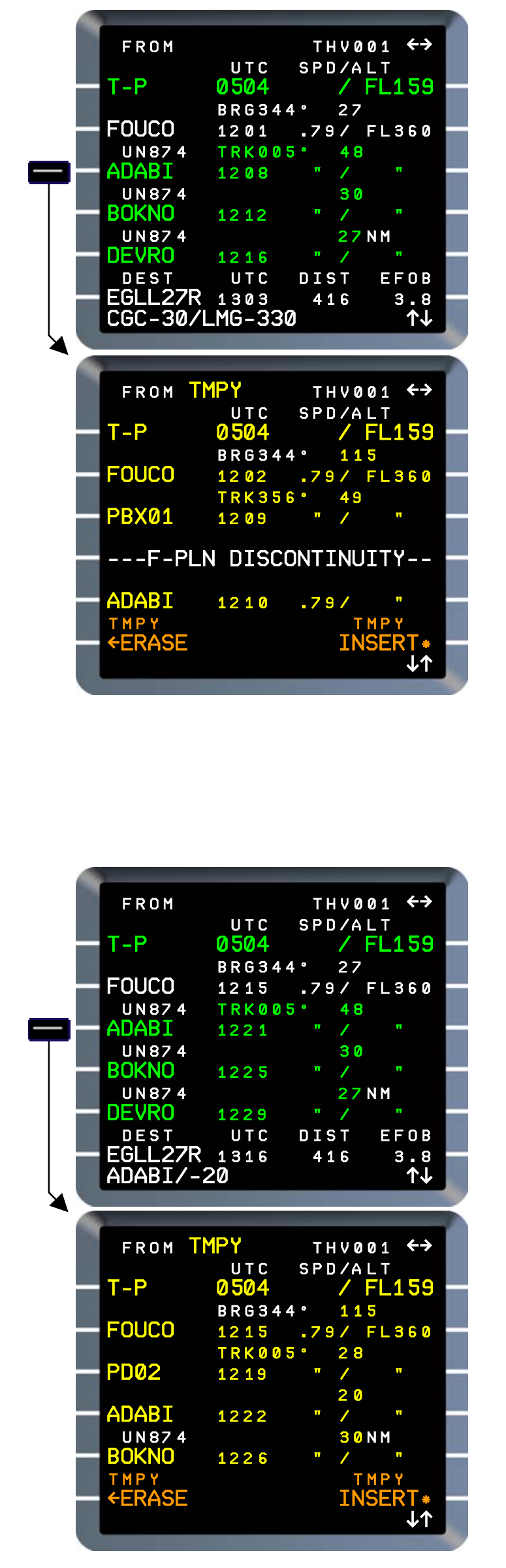
Manufacturer reference: PB/PB and PLACE/DIST point definitions in Thales FMS2 REV1. The CGC/LMG/ADABI examples illustrate source geometry only; exact accepted V3 format and generated identities must be read on the loaded unit. [66, PDF p. 654]